Proximity to Greenspace and Outdoor Recreation
Access to a broad range of recreational opportunities can play an important role in promoting exercise, physical fitness, and healthier lifestyles. This map series explores the distribution of greenspace and recreation resources across the region. It includes maps showing (a) proximity to publicly accessible parks; (b) proximity to publicly accessible natural areas; (c) proximity to locations for accessing the water by boat; (d) proximity to recreation facilities such as sports fields and swimming pools; and (e) proximity to greenspaces that are available for limited public use, such as school sports fields. The series also includes a composite heatmap that combines all of the indicators, and a version of the composite map that shows access by neighborhood.
The next map series, Proximity to Greenspace and Outdoor Recreation in Relationship to Demographic Patterns, layers the composite map with demographic maps to assess potential disparities in the distribution of greenspace and outdoor recreation resources.
What the Maps Tell Us: Initial Findings
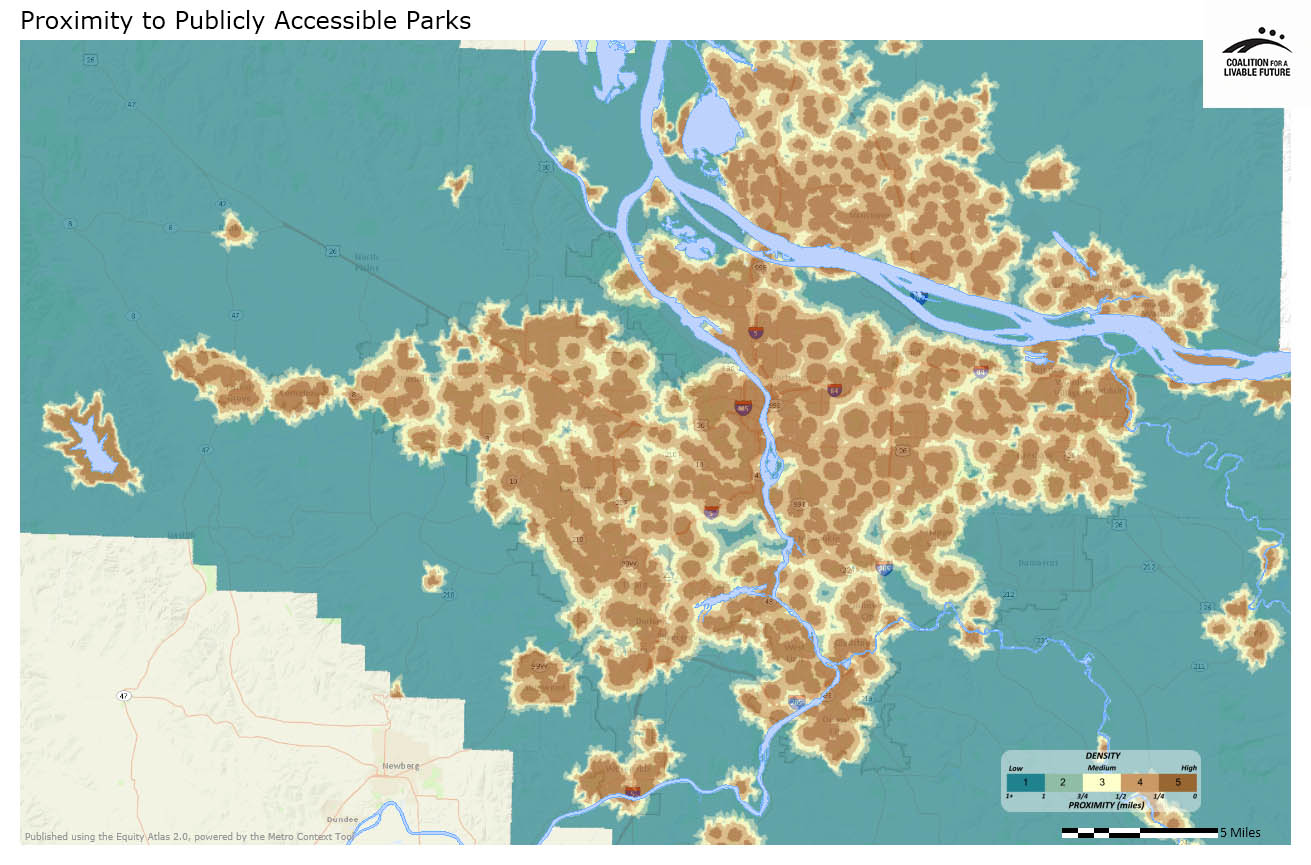
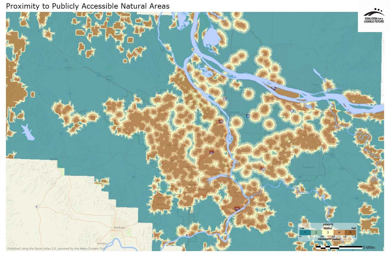
This map series includes the Proximity to Publicly Accessible Parks and Proximity to Publicly Accessible Natural Areas maps that are analyzed in the Proximity to Parks and Natural Areas map series. It also includes maps analyzing other forms of greenspace and outdoor recreation.
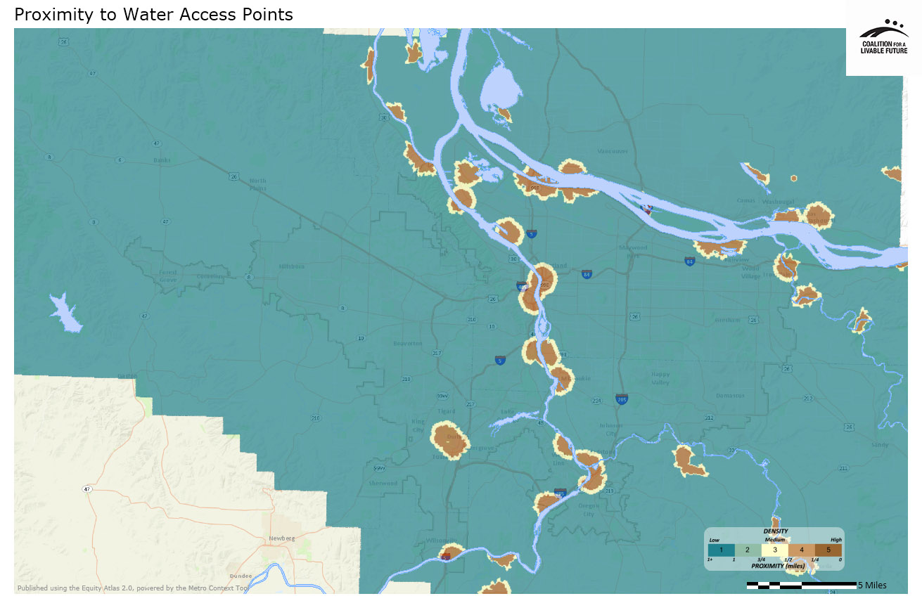
The Proximity to Water Access Points map, not surprisingly, indicates that the locations in the region with the best access to water recreation tend to be located in neighborhoods along the Willamette and Columbia Rivers. The Atlas mapping tool can be used to assign a proximity score to every neighborhood in the region based on the average proximity of every block in the neighborhood to a particular resource. A score of “5” indicates proximities within ¼ mile, while a score of “1” or below indicates proximities greater than 1 mile. Due to the nature of the data, the proximity index for the Water Access Points map is different than many of the other Atlas maps in that the highest numerical value given to any neighborhood in the region is 3.38, significantly lower than the score of 5 that represents the highest scores on most indicators. This results in a fairly monotone map with little color variation. The neighborhoods with the highest proximity scores to water access points are:
- Bridgeton (Portland)
- Downtown (Portland)
- Lloyd District (Portland)
- McLoughlin (Oregon City)
- Old Town/Chinatown (Portland)
- Waverly-Downtown (Milwaukie)
Interestingly, the neighborhoods with the lowest proximity to water access points are not necessarily landlocked, as one might expect. Low scoring neighborhoods like West Hazel Dell in Vancouver and Brooklyn in Portland actually have a great deal of water frontage that is simply inaccessible to the public at large. The neighborhoods with the lowest proximity scores to water access points are:
- Brooklyn (Portland)
- Canemah (Oregon City)
- East Old Evergreen Highway (Clark County)
- Lakewood (Lake Oswego)
- Riverview (Vancouver)
- West Hazel Dell (Vancouver)
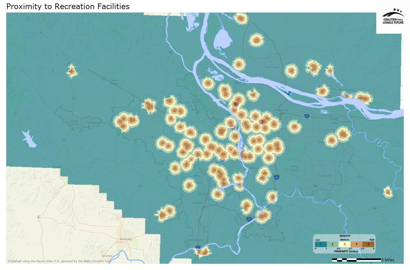
The Proximity to Recreation Facilities map focuses on proximity to publicly accessible facilities, typically managed by local parks departments, including community centers, swimming pools, tennis courts, and sports fields. The neighborhoods with the highest proximity to these recreation facilities are primarily in Lake Oswego:
- Arlington Heights/Sylvan-Highlands (Portland)
- Grant Park (Portland)
- Holly Orchard (Lake Oswego)
- John’s Woods (Lake Oswego)
- McLoughlin (Oregon City)
- Mountain Park (Lake Oswego)
- Old Town (Lake Oswego)
The neighborhoods with the lowest proximity to recreation facilities are primarily located in industrial, unincorporated, and less densely populated areas.
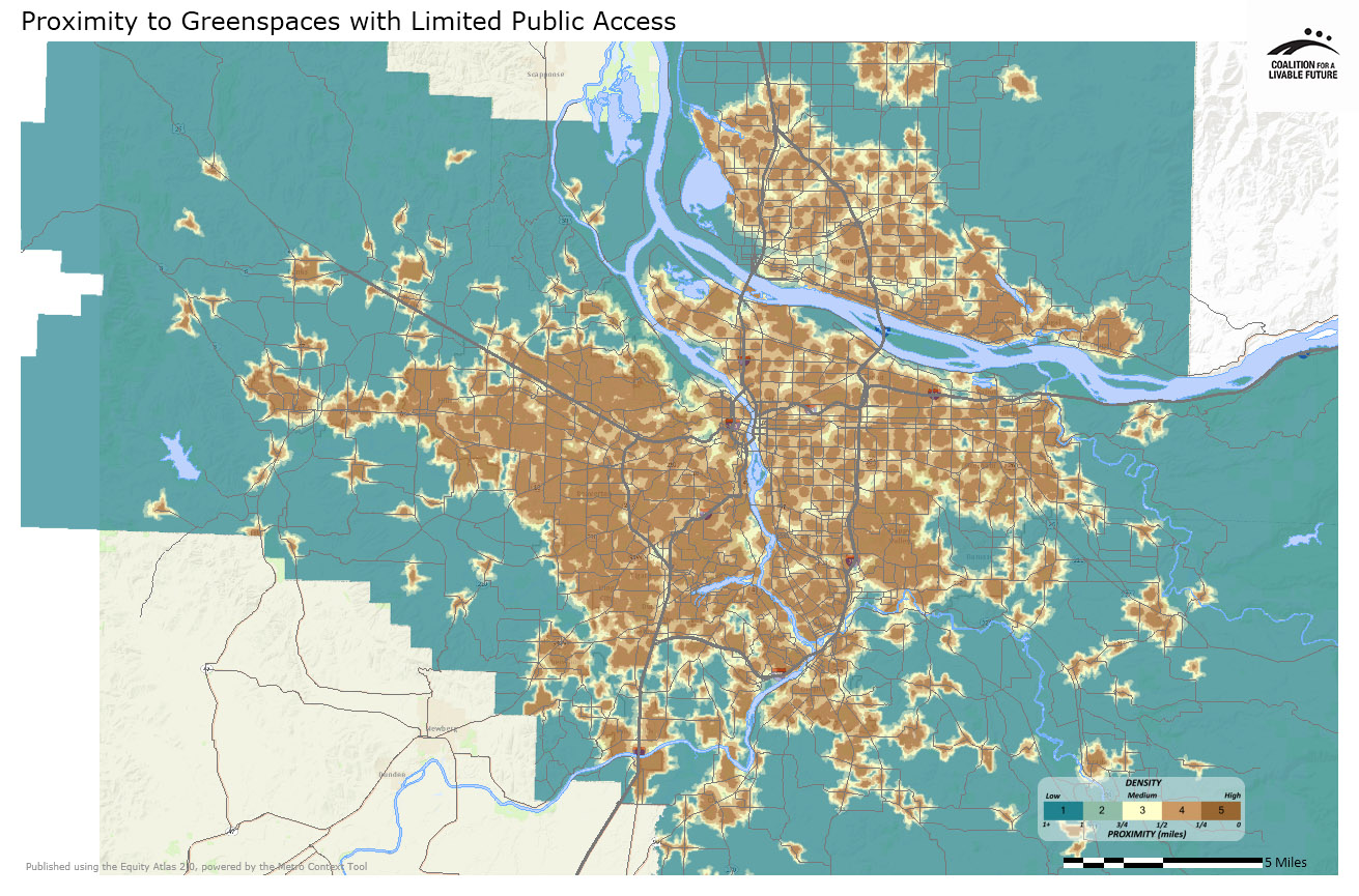
The Proximity to Greenspaces with Limited Public Access map focuses on places like public school playgrounds and sports fields that are available to the public but during limited hours. Fourteen neighborhoods in the region earned a high score of 5 on this indicator. As with the other greenspaces indicators, neighborhoods in Lake Oswego and Portland feature prominently on this list:
- Airport Green (Vancouver)
- Boise/Eliot (Portland)
- Eastmoreland/Reed (Portland)
- Eastmoreland/Ardenwald – Johnson Creek (Portland)
- Goose Hollow/Southwest Hills (Portland)
- Hillside/Northwest District (Portland)
- Holly Orchard (Lake Oswego)
- John’s Woods (Lake Oswego)
- Mountain Park (Lake Oswego)
- Neighbors Southwest (Beaverton)
- Northfield (Vancouver)
- North Hearthwood (Vancouver)
- Northwest Heights (Portland)
- Parker Crest (West Linn)
Nine of the ten neighborhoods earning the lowest scores on the Proximity to Greenspaces with Limited Public Access map are located in Clark County. This could potentially be due to differences in how Clark County and Metro designate such areas, or it could reflect actual differences in accessibility to these resources between Clark County and the Oregon portions of the region:
- Carter Park (Vancouver)
- East Fork Frontier (Clark County)
- East Fork Hills (Clark County)
- Esther Short (Vancouver)
- Fruit Valley (Vancouver)
- Hockinson (Clark County)
- Hough (Vancouver)
- Linnton (Portland)
- North Fork Lewis River (Clark County)
- Proebstel (Clark County)
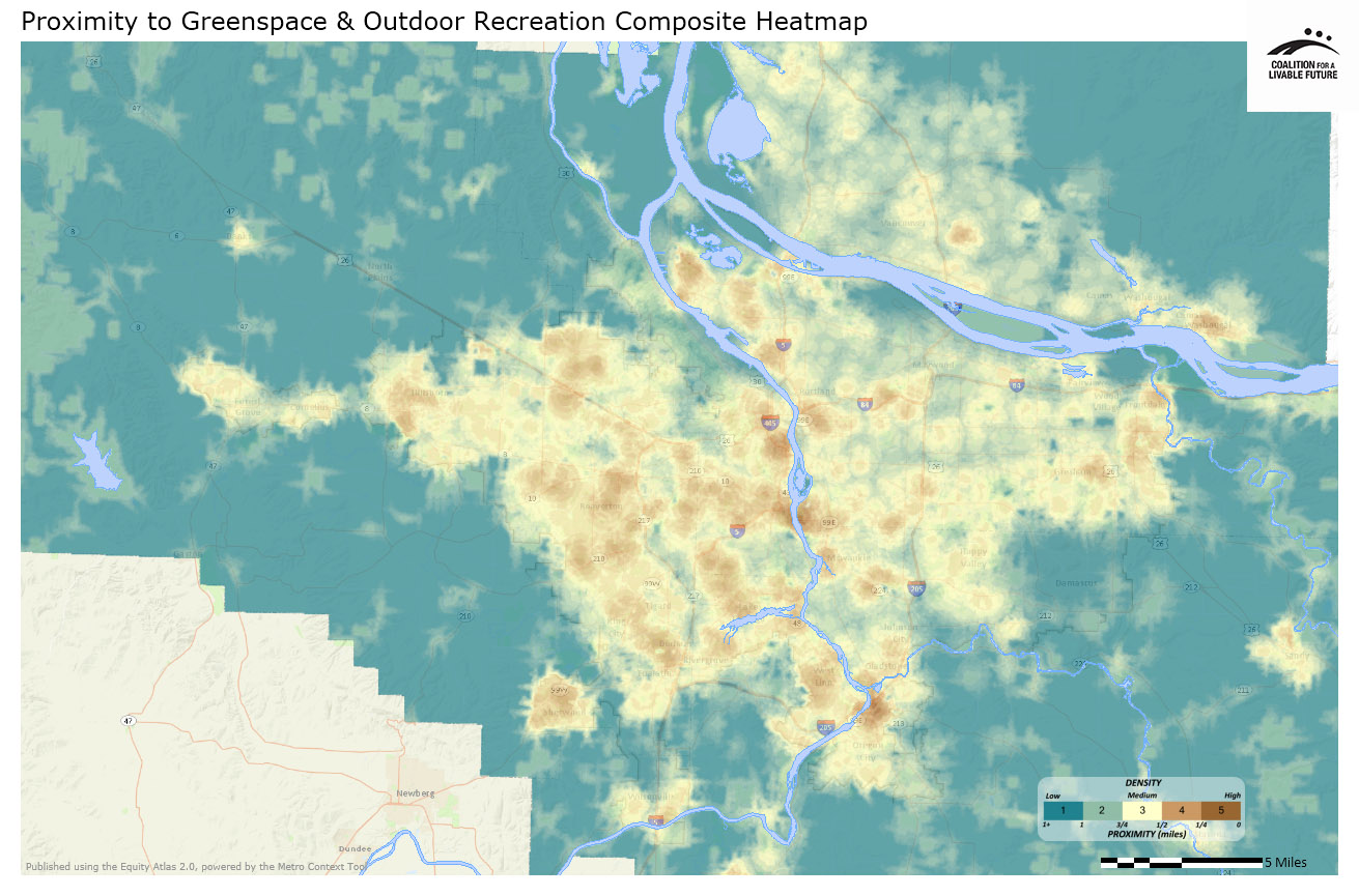
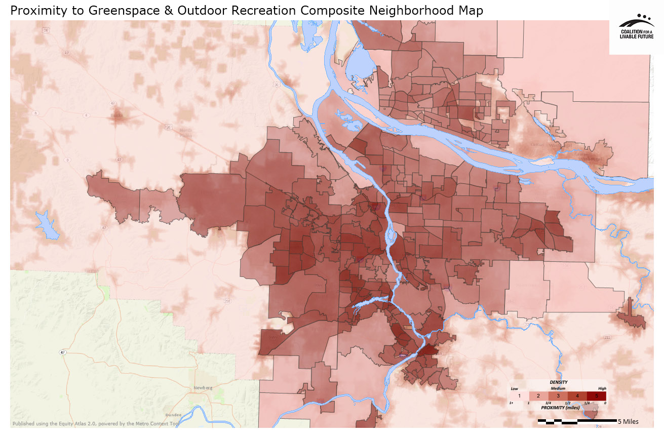
The Proximity to Greenspace and Outdoor Recreation Composite map tells a more comprehensive story about overall access to parks and open space. The table below lists the ten neighborhoods across the region with the highest scores on the proximity to greenspace and outdoor recreation composite index and shows how each element of the composite measure contributed to their high composite scores:
|
Neighborhood |
Location |
Proximity to Parks |
Proximity to Natural Areas |
Proximity to Greenspaces |
Proximity to Water Access Points |
Proximity to Recreational Facilities. |
|---|---|---|---|---|---|---|
|
McLoughlin |
Oregon City |
4.65 |
4.48 |
4.42 |
2.50 |
4.26 |
|
Holly Orchard |
Lake Oswego |
4.42 |
4.88 |
5.00 |
1.00 |
4.30 |
|
Old Town |
Lake Oswego |
5.00 |
4.82 |
4.04 |
1.00 |
4.46 |
|
Hidden Springs |
West Linn |
4.81 |
5.00 |
4.72 |
1.01 |
3.66 |
|
Highland |
Beaverton |
4.36 |
4.87 |
4.93 |
1.00 |
3.93 |
|
Portland |
4.78 |
4.00 |
5.00 |
1.00 |
4.17 |
|
|
South Burlingame |
Portland |
4.82 |
3.88 |
4.69 |
1.91 |
3.65 |
|
Far Southwest |
Portland |
4.14 |
4.95 |
4.81 |
1.00 |
4.10 |
|
Goose Hollow |
Portland |
4.96 |
4.66 |
4.79 |
1.03 |
3.30 |
|
Hallinan |
Lake Oswego |
4.96 |
4.96 |
4.64 |
0.99 |
3.31 |
|
Parker Crest |
West Linn |
4.68 |
4.93 |
5.00 |
1.00 |
3.14 |
|
Westridge |
Lake Oswego |
4.62 |
4.47 |
4.91 |
1.00 |
3.82 |
|
Mountain Park |
Lake Oswego |
3.96 |
4.48 |
5.00 |
1.00 |
4.3 |
The next map series analyzes how access to parks, greenspaces, and recreation relates to demographic patterns, and what this means from an equity perspective.
About the Maps
Proximity to Publicly Accessible Parks
This map shows proximity to parks that are open to public use, regardless of whether they are publicly owned. Parks are defined as active or passive recreation areas where facilities exist that are primarily intended for recreational uses by the public. Proximity is measured based on street grid access to park entrances.
Data Source: Metro RLIS (2012) and Clark County GIS (2012)
Proximity to Publicly Accessible Natural Areas
This map shows proximity to natural areas managed primarily for the value of natural resources, the use of environmental buffers, conservation and/or habitat protection. Proximity is measured based on street grid access to park entrances.
Data Source: Metro RLIS (2012) and Clark County GIS (2012)
Proximity to Water Access Points
This map shows proximity to points where motorized and non-motorized boats can be launched. These sites have parking areas for cars and include boat ramps managed by both public agencies and private organizations. The data sets for Oregon and Washington are fairly old, but represent the most complete dataset publicly available.
Data Source: Oregon Geospatial Enterprise Project (1989); Washington State Recreation and Conservation Office (2003)
Proximity to Recreation Facilities
This map shows proximity to publicly owned and publicly accessible recreation facilities, many of which are located in public parks and greenspaces and operated by local parks departments. It includes swimming pools, tennis courts, sports fields, community centers, stadiums, and fairgrounds. The map does not include private recreation facilities such as health clubs, gyms, and private swimming pools.
Data Source: Metro RLIS (2012) and Clark County GIS (2012)
Proximity to Greenspaces with Limited Public Access
This map shows proximity to greenspaces that have limited public access. This includes school sports fields and playgrounds that are only available for public use during designated hours, common areas of subdivision and condominium complexes, cemeteries, and golf courses.
Data Source: Metro RLIS (2012) and Clark County GIS (2012)
Proximity to Greenspace and Outdoor Recreation Composite Heatmap
This map combines the proximity scores from the Proximity to Publicly Accessible Parks, Proximity to Publicly Accessible Natural Areas, Proximity to Water Access Points, Proximity to Greenspaces with Limited Public Access, and Proximity to Recreation Facilities maps to create a composite heatmap.
Data Source: Metro RLIS (2012); Clark County GIS (2012); Oregon Geospatial Enterprise Project (1989); Washington State Recreation and Conservation Office (2003)
Proximity to Greenspace and Outdoor Recreation Composite Neighborhood Map
This map uses the same underlying data as the Proximity to Greenspace and Outdoor Recreation Composite Heatmap, but instead of showing the data as a heatmap, it aggregates the data by neighborhood. The darker the neighborhood, the higher its proximity score.
Data Source: Metro RLIS (2012); Clark County GIS (2012); Oregon Geospatial Enterprise Project (1989); Washington State Recreation and Conservation Office (2003)
*Some neighborhood boundaries overlap. The Atlas refers to the areas within the overlapping boundaries by the names of both neighborhoods.
|
This document was downloaded from the Map Series library of the Coalition for a Livable Future’s Regional Equity Atlas 2.0 website. The Regional Equity Atlas is a research and education project to promote widespread opportunity for a stronger, healthier, and more sustainable Portland-Vancouver metropolitan region. For more information, visit www.equityatlas.org. |
